Jun 6, 2008 · KML
Green Buildings in California
I like taking data that is thrown up on a map in a completely ad-hoc format and freeing it into an actually usable format. In this case, I recently saw the new State of California's Green Building Directory (via geospatial reddit).
What is particularly funny about this project is its use of the term "GIS Technologies" to describe a very archaic map with stand-up pins. A GoogleMap is not GIS. The original site does allow users to search by specific attributes, but not really in a dynamic way.
The map is created by directly building markers up in Javascript. Assumedly the back-end is powered by a database, and it would have been nice of them to share out an actual listing of the underlying data. This is a perfect example of the study .gov web sites should focus on RSS, XML'”not redesigns.
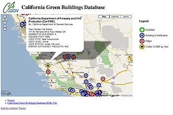
So instead I just created a KML version that uses Extended Data to call out the various attributes on the features such as LEED rating and number of buildings. You can see my own mashup and grab the KML file.
As I said before, this map I made isn't "GIS". But consider I spent about 5 minutes with the original Javascript and a bunch of RegExps to create the KML. It's up to you to make something useful with it.